Jezioro Anterselva - naturalny klejnot w dolinie Anterselva
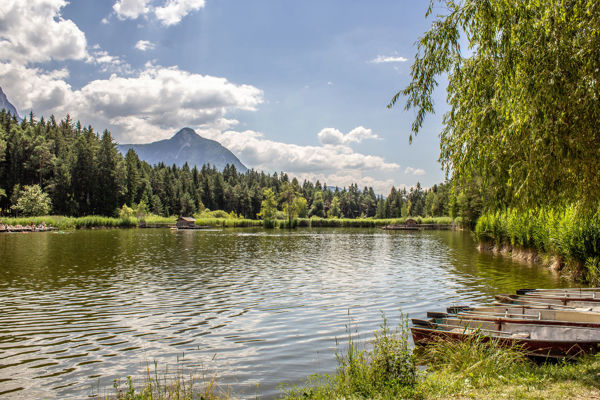
Jezioro Anterselva położone jest w imponującej górskiej scenerii Parku Przyrody Rieserferner-Ahrn. Otoczone gęstymi lasami i majestatycznymi szczytami, jest popularnym celem wycieczek pieszych, miłośników przyrody i osób szukających ciszy i spokoju. Niezależnie od tego, czy chodzi o spokojne spacery wzdłuż brzegu, uprawianie sportu, czy po prostu podziwianie i wzięcie głębokiego oddechu - trzecie co do wielkości jezioro w Południowym Tyrolu zachwyca o każdej porze roku.

Hotel on Lake Antholz, in an exclusive location right by the water
Unsplash / Andrea MaioloFakty i liczby dotyczące malowniczego górskiego jeziora
- Lokalizacja: na czele doliny Anterselva, w parku przyrody Rieserferner-Ahrn
- Wysokość: 1 642 metrów nad poziomem morza
- Powierzchnia: ok. 44 ha
- Maksymalna głębokość: 38 metrów
- Formacja: prawdopodobnie w wyniku osunięcia się ziemi
- Cechy szczególne: trzecie co do wielkości naturalne jezioro w Południowym Tyrolu, często całkowicie zamarznięte zimą
- Nazwa włoska: Lago di Anterselva

Lake Antholz in Pustertal is located at 1642 m above sea level and is up to 38 m deep.
Internet ConsultingOd jeziora lodowcowego do mekki biathlonu
Jezioro Anterselva powstało prawdopodobnie w wyniku osunięcia się ziemi, które zamknęło dolinę i zablokowało odpływ wody. Znana legenda opowiada jednak o trzech bogatych rolnikach, których gospodarstwa zostały zalane przez nagłe źródło po odrzuceniu żebraka - historia ta nadaje jezioru mistyczny charakter.
Dziś jezioro jest nie tylko miejscem spokoju, ale także miejscem międzynarodowych wydarzeń sportowych: Tuż obok znajduje się Południowym Tyrolu Arena, słynne centrum biathlonu w Anterselva. Każdego roku w styczniu zbierają się tu najlepsi biathloniści na świecie - ekscytujący kontrast dla spokojnego jeziora.

Just behind the border crossing at the Staller Sattel Pass is the picturesque Lake Obersee.
Internet ConsultingBlisko granicy i Staller Sattel
Jezioro Anterselva znajduje się zaledwie kilka kilometrów od granicy z Austrią. Pobliski Staller Sattel łączy Południowy Tyrol ze wschodniotyrolską doliną Defereggen. Kręte podejście przez gęsty las i kwitnące alpejskie łąki jest przeżyciem samym w sobie.
Po dotarciu na szczyt, odwiedzających wita zapierający dech w piersiach widok na dwa regiony charakteryzujące się wspólnymi skarbami natury, ale każdy z własną kulturą i kuchnią. Jezioro Obersee, tuż za granicą, jest kolejnym wartym odwiedzenia celem krótkiej wycieczki - szczególnie dla turystów pieszych i motocyklistów.


Atrakcje wokół jeziora Anterselva

The hiking trail around Lake Antholz runs partly on a wooden footbridge.
Internet ConsultingJezioro Anterselva zachwyca odwiedzających przez cały rok swoim naturalnym pięknem i szeroką gamą możliwości spędzania wolnego czasu. Połączenie dziewiczej przyrody, ekscytującej flory i fauny oraz możliwości uprawiania sportu sprawia, że miejsce to jest prawdziwą atrakcją dla miłośników przyrody i aktywnych wczasowiczów.
Turystyka piesza, rowerowa i odkrywanie przyrody
W cieplejszych miesiącach jezioro Anterselva zachęca do aktywności. Okrężny szlak wokół jeziora - który jest również ekscytującą ścieżką przyrodniczą - jest idealny dla rodzin, spacerowiczów i każdego, kto chce wybrać się na spokojny spacer. Dla tych, którzy wolą coś bardziej sportowego, dostępne są liczne wędrówki po okolicznych górach, na przykład do Steinzger Alm lub Rieserfernerhütte.
Możliwe są również wycieczki rowerem górskim przez dolinę Antholz lub do Staller Sattel - fantastyczna sceneria zawsze Ci towarzyszy. Słoneczne wybrzeża zachęcają do piknikowania, czytania lub robienia zdjęć. Przyroda wokół jeziora pokazuje swoje najbardziej kolorowe oblicze, szczególnie wiosną i jesienią.

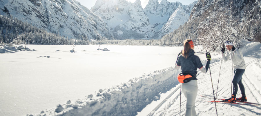
The valley of Antholz is the valley of biathlon and cross-country skiing and offers wonderful panoramic tracks.
Tourismusverein Antholzertal - Manuel KotterstegerSporty zimowe i gorączka biathlonu
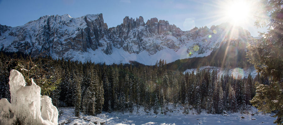
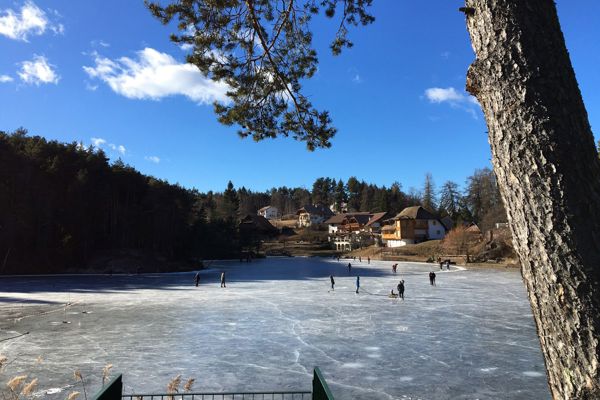
Gdy tylko spadnie pierwszy śnieg, krajobraz wokół jeziora Anterselva zamienia się w zimową krainę czarów. Region słynie z doskonale przygotowanych tras do narciarstwa biegowego, które są częścią sieci Dolomiti NordicSki. Szczególnie centrum biathlonowe Południowego Tyrolu przyciąga entuzjastów sportu z całego świata - regularnie odbywają się tu spektakularne wyścigi biathlonowe.
Jeśli chcesz się zrelaksować, możesz odkrywać zaśnieżoną okolicę podczas wycieczki na rakietach śnieżnych lub zimowej wędrówki wokół jeziora. Jeśli pokrywa lodowa jest wystarczająco stabilna, bezpośrednio na zamarzniętym jeziorze znajduje się trasa do narciarstwa biegowego, a także zimowy szlak turystyczny.
Dojazd do jeziora Anterselva
Do jeziora Anterselva można dojechać drogą krajową SS49 przez Val Pusteria. Jadąc z zachodu, należy skręcić w lewo w dolinę Anterselva krótko za Valdaorą i podążać drogą Anterselva przez około 17 kilometrów do jeziora. Jedyny parking znajduje się w centrum biathlonowym Anterselva, zaledwie kilka minut spacerem od jeziora. Opłaty za parking różnią się w zależności od pojazdu i pory dnia.
Jezioro Anterselva jest również łatwo dostępne środkami transportu publicznego. Najbliższa stacja kolejowa znajduje się w Valdaora. Linia autobusowa 431 regularnie łączy jezioro z Valdaora i Brunico.

Oberrasen liegt auf 1.080 bis 1.110 Meter Meereshöhe.
Internet ConsultingInne miejsca w okolicy
- Rasun-Anterselva: W dolinie Anterselva znajduje się 5 małych wiosek - Nieder- i Oberrasen, Anterselva Niedertal, Mittertal i Obertal, ze sklepami, kawiarniami, restauracjami i zakwaterowaniem.
- Biotop Rasner Möser: Biotop w Oberrasen to obszar wrzosowisk, który jest rezerwatem przyrody. Można tu odkryć wiele wyjątkowych zwierząt i roślin.
- Valdaora: Ośrodek wypoczynkowy w centrum Val Pusteria oferuje dobre połączenia komunikacyjne, szeroki wybór zakwaterowania i szybki dostęp do terenu narciarskiego Plan de Corones w zimie.
- Brunico: Centrum Val Pusteria znajduje się około 30 minut od jeziora. Ze swoją zabytkową starówką, muzeami, butikami i restauracjami, Brunico jest idealnym miejscem na spacer po mieście.

info@bruneck.com
www.bruneck.com
Często zadawane pytania
Czy w jeziorze Anterselva można pływać?
Zasadniczo tak. Jednak woda pozostaje bardzo chłodna nawet w środku lata - orzeźwienie dla wytrwałych!
Czy można wędrować wokół jeziora Anterselva?
Tak, istnieje łatwa trasa okrężna wokół jeziora Anterselva. Ma ona około 4 km długości i zajmuje około 1,5 godziny.
Czy jezioro Anterselva jest dostępne zimą?
Tak, jezioro jest dostępne przez cały rok. To, czy ścieżka wokół jeziora jest dostępna, zależy od warunków śniegowych. Jednak okolica jest idealna do uprawiania narciarstwa biegowego, wędrówek na rakietach śnieżnych i zimowych wędrówek. Jeśli lód jest dobry, istnieje również zimowy szlak turystyczny bezpośrednio na zamarzniętym jeziorze.
Czy nad jeziorem można zatrzymać się na posiłek?
Tak, tuż nad brzegiem jeziora znajduje się restauracja, a w okolicy są także chaty, w których można coś przekąsić.
Zdjęcia

Seen from above: Drone shots of Lake Antholz and the winding road up to the Staller Sattel Pass.
Internet Consulting
At the end of the Antholz valley, shortly after Lake Antholz, a road wind its way up to the Staller Sattel Pass.
Internet Consulting
The Staller Sattel Pass is around 4 kilometres from the famous Lake Antholz.
Internet Consulting
You can also hike directly from Lake Antholz up to the Staller Sattel Pass.
Internet Consulting
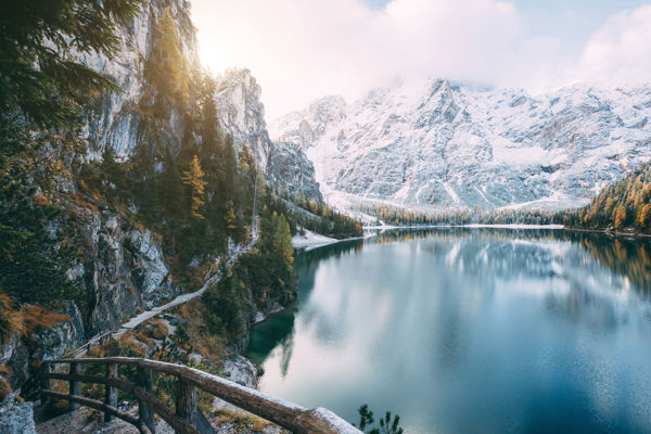
The water of Lake Antholz, which is around 38 metres deep, shimmers turquoise-green.
Internet Consulting
On the north and south shores of Lake Antholz there are several cosy places to take a break.
Internet Consulting
A leisurely hiking trail leads around Lake Antholz.
Internet Consulting
The hiking trail around Lake Antholz runs partly on a wooden footbridge.
Internet Consulting
With games and information about animals and plants, the Nature Trail at Lake Antholz is particularly exciting for children.
Internet Consulting
Nature lovers get their money's worth at Lake Antholz.
Internet Consulting
The Nature Trail with numerous information boards around the lake is dedicated to the local flora and fauna.
Internet Consulting
L'area relax sulla riva sinistra del lago è un luogo dove rilassarsi e distendersi.
Internet Consulting
The hike around Lake Antholz takes approx. 1.5-2 hours and is an experience for young and old.
Internet Consulting
Lake Antholz in Pustertal is located at 1642 m above sea level and is up to 38 m deep.
Internet Consulting
Each viewpoint is worth a photo!
Internet Consulting - Sabine Oberheinricher
A visit to the magnificent Lake Antholz is a must for every holidaymaker in the Antholz valley.
Internet Consulting
Surrounded by the mountains of the Rieserferner group, Lake Antholz lies at the head of the Antholz valley.
Internet Consulting
In winter, Lake Antholz near Rasen-Antholz is a good starting point for many winter sports, such as tobogganing or ski touring.
Tourismusverein Antholzertal - Manuel Kottersteger
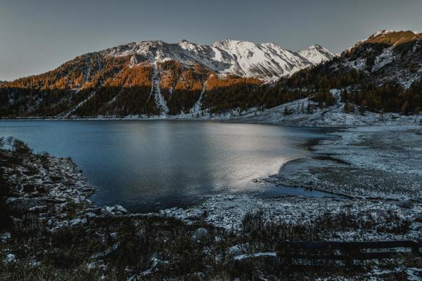
In autumn, the larches around Lake Antholz have golden colours. At this time of the year, there may sometimes be the first snow.
Tourismusverein Antholzertal - Manuel Kottersteger
The dog Willy enjoys the magnificent hike around the picturesque Lake Antholz.
Internet Consulting - Sabine Oberheinricher
The lake is located at 1,642 meters above sea level and the maximum depth is 38 meters.
Internet Consulting - Sabine Oberheinricher
The road to the Staller passes is right by the lake.
Internet Consulting
The path around the lake
Internet Consulting